Severe storms with intense tornadoes expected to continue in Central US through Monday
Severe Storms with Intense Tornadoes Expected to Continue in Central US Through Monday
Severe storms with intense tornadoes expected – Following a relatively calm May, the central United States is now witnessing a surge in severe weather activity. A volatile stretch of thunderstorms has begun to develop across the Plains and Midwest, set to persist through Tuesday. This weather system poses a serious risk of powerful tornadoes—rated EF3 or stronger—as well as destructive hail, damaging winds, and heavy rainfall. The Central Plains, known for their susceptibility to springtime storms, are bracing for a potentially dangerous sequence of weather events that could rival historical patterns.
Sunday’s Storm Surge and Tornado Emergencies
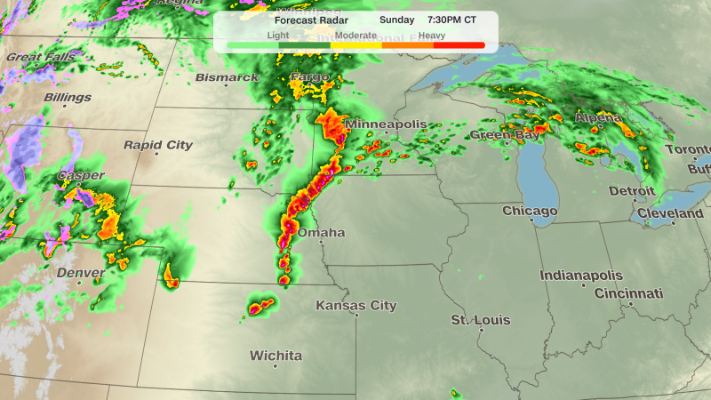
Sunday marked the initial phase of the severe weather outbreak, with thunderstorms rapidly intensifying across Nebraska and southeastern South Dakota. The National Weather Service reported that a tornado was confirmed north of Grand Island, Nebraska, while a tornado emergency—a rare designation reserved for situations where a large, damaging tornado is imminent—was issued near Hebron, Nebraska, around 6:30 p.m. CT. This emergency alert underscores the critical nature of the situation, as forecasters are confident in the severity of the approaching storms.
“A tornado emergency is issued only when forecasters are certain that a large, damaging tornado is incoming,” said the National Weather Service.
By late afternoon, the storm system began to consolidate into a line, enhancing the threat of damaging winds exceeding 80 mph. The tornado watches, covering over four million residents in central Nebraska, southeastern South Dakota, much of Kansas, western Iowa, and southern Minnesota, indicate that the region is under intense monitoring. Cities like Omaha and Lincoln, Nebraska, and Sioux City, Iowa, are within the high-risk zones, with weather officials warning of persistent threats throughout the evening.
Monday’s Peak Risk and Storm Dynamics
Monday is expected to be the most active day of the severe storm cycle, driven by a significant increase in jet stream energy interacting with ample moisture in the Plains. The Storm Prediction Center has raised the risk to a rare Level 4 out of 5, signaling a high likelihood of tornadoes—some potentially EF2 or stronger—along with large hail. This surge in activity will concentrate from central and eastern Kansas into southeastern Nebraska and northwestern Missouri, where the danger remains substantial.
While tornadoes are the primary concern on Monday, damaging winds are projected to become the dominant threat by late evening. However, the possibility of tornadoes persists into the overnight hours, depending on how the storms evolve. One key uncertainty lies in the morning’s weather conditions, as the presence of storm clouds and cloud cover may influence the afternoon’s energy levels. Areas where storms linger overnight from Sunday are likely to experience reduced intensity, which could affect the magnitude of tornado threats on Monday.
Tuesday’s Transition and Fire Risks
As the storm system shifts eastward on Tuesday, the threat of severe thunderstorms will gradually decrease, though activity is still expected to persist. The Storm Prediction Center has issued a Level 2 risk across a broader swath of the central U.S., from northern Texas to Michigan, with stronger storms likely to emerge in the afternoon. While tornadoes will become less frequent, wind and hail will remain significant hazards, particularly in regions where the cold front begins to dominate.
Simultaneously, the same atmospheric conditions fueling the tornado outbreak are contributing to a heightened risk of wildfires in the Southern High Plains. The National Weather Service has classified the fire threat as extremely critical, with areas from southwestern Kansas to the Texas Panhandle and northeastern New Mexico facing the highest risk. A Level 3 fire threat—indicating very high danger—covers these regions, while a Level 2 threat spans much of New Mexico. The combination of dry fuels, sustained winds between 25 and 30 mph, and gusts up to 50 mph, along with relative humidity dropping below 10%, creates ideal conditions for rapid fire spread.
“Sustained winds of 25 to 30 mph, gusts up to 50 mph, and relative humidity under 10% will combine with dry fuels to cause any fires that ignite to spread at a life-threatening pace,” stated the National Weather Service.
The shift in the jet stream pattern, which initially suppressed severe storms, has now transitioned into a catalyst for extreme weather. This dynamic is particularly notable in the Central Plains, where the interplay between warm, moist air and cooler, drier air masses has created instability. The result is a scenario where tornadoes and wildfires are both potential hazards, with the Midwest and Southwest experiencing contrasting impacts from the same weather system.
Historically, May has been a critical month for severe weather in the central U.S., with the region often seeing the peak of tornado season. This year’s outbreak aligns with that trend, emphasizing the need for vigilance from residents and emergency responders. The confirmed tornado in Nebraska and the tornado emergency in Hebron highlight the immediate danger, while the broader risk across the central U.S. suggests that the worst is yet to come. As the storm system progresses, its movement will dictate whether the threat remains concentrated or spreads further.
For those in the path of the storms, the importance of staying informed and prepared cannot be overstated. The National Weather Service is actively monitoring conditions, issuing updated alerts as necessary. Meanwhile, communities in the Southwest should remain alert for fire dangers, as dry conditions and strong winds could lead to uncontrollable blazes. The convergence of these weather threats underscores the complexity of May’s climate patterns and the potential for widespread impacts.
Experts suggest that the severity of the storms is influenced by the jet stream’s recent behavior, which has created a more conducive environment for tornado formation. The interaction of this energy with moisture from the Gulf of Mexico has led to the development of super
